In a landmark moment for space science, the NASA-ISRO Synthetic Aperture Radar (NISAR) satellite has sent back its first radar images of Earth’s surface, showcasing the incredible potential of the joint Indo-US mission. Launched earlier this year, NISAR is designed to provide unparalleled insights into changes in the planet’s ecosystems, ice cover, vegetation, and tectonic shifts. The initial radar images captured sprawling forests, mountainous regions, and coastal zones with remarkable detail, reaffirming the satellite’s ability to monitor even the smallest environmental transformations with accuracy.
The NISAR mission represents one of the most ambitious collaborations between NASA and the Indian Space Research Organisation (ISRO). The satellite uses two frequency radar systems—L-band and S-band—making it the first radar imaging satellite of its kind. This dual capability allows it to penetrate through vegetation and cloud cover, enabling scientists to study regions that optical satellites cannot observe effectively. The newly released images demonstrate the satellite’s precision, mapping subtle changes in land and water surfaces, which will prove vital in tackling issues such as deforestation, flooding, and urban expansion. Experts have hailed the achievement as a game-changer for Earth observation.
Beyond its scientific contributions, NISAR holds immense importance for disaster management and climate change research. The satellite’s ability to provide near real-time data will help track natural disasters such as earthquakes, landslides, and cyclones, enabling quicker response strategies. Additionally, it will contribute to global climate monitoring by observing shifts in polar ice sheets and rising sea levels. For India, the data promises to be particularly useful in agriculture, water resource management, and planning sustainable urban growth. The successful transmission of its first radar images marks the beginning of what scientists call a “new era” in satellite Earth observation.
Strategic Significance of NISAR
The joint satellite project has both scientific and geopolitical significance. By sharing data, India and the United States aim to build stronger collaborative networks in space technology. For India, this mission strengthens its growing reputation as a leader in cost-effective space exploration, while also expanding its capacity to tackle pressing national challenges such as food security and disaster mitigation. For the US, NISAR adds a valuable tool to its Earth science arsenal, reinforcing its global commitment to climate action. Together, the project sets a precedent for international cooperation in addressing global environmental concerns.
The mission’s success is also expected to inspire new partnerships and encourage young scientists in both countries to pursue careers in space and Earth sciences. Universities and research institutions are already preparing to use NISAR’s data for projects ranging from glacier studies to crop pattern analysis. This cross-border exchange of knowledge will further deepen ties in scientific research, demonstrating that space technology can serve as a bridge between nations while delivering tangible benefits to humanity.
Future of Earth Observation
The release of the first radar images is only the beginning of NISAR’s long-term mission. Over the next three years, the satellite will map the entire globe in 12-day cycles, creating an unprecedented archive of Earth’s changing surface. Scientists expect this wealth of data to transform environmental research, offering predictive models for climate impacts, biodiversity loss, and natural hazards. As global challenges mount, NISAR’s insights could prove invaluable in shaping policies and strategies to protect the planet. The mission is not just about observing Earth—it is about safeguarding its future.
One of the most striking aspects of the first images released by NISAR is the unprecedented level of detail they reveal. Unlike traditional optical images that rely on visible light, radar imaging works by bouncing microwaves off Earth’s surface, allowing it to capture information in all weather conditions, day or night. This makes NISAR uniquely capable of observing areas often hidden by monsoon clouds, dense forests, or polar darkness. The radar images show variations in land textures, soil moisture, and vegetation density, giving researchers new tools to study Earth’s constantly changing environment.
The data from NISAR is expected to revolutionize agriculture monitoring in India and beyond. By identifying subtle changes in crop growth, soil conditions, and water availability, the satellite will empower farmers with information to improve yields and reduce losses. Indian agricultural scientists are particularly optimistic about its role in tackling challenges related to food security. Real-time analysis of crop health could help governments design better support systems for farmers, issue timely advisories, and ensure efficient use of water and fertilizers, making agriculture more resilient to climate shocks.
Another major benefit of NISAR lies in disaster preparedness. In a country like India, where floods, landslides, and cyclones are frequent, early detection of ground deformation and rainfall impacts is crucial. The satellite’s radar can detect even minute shifts in land surfaces, allowing scientists to predict landslides or track flooding patterns. This capability can guide disaster response agencies to act quickly, relocate communities, and save lives. International organizations, too, will be able to use the data for humanitarian purposes in other vulnerable regions across Asia and Africa.
Environmental conservationists believe NISAR will play a pivotal role in protecting forests and biodiversity. The satellite can map deforestation at a granular level, track illegal logging activities, and monitor forest regrowth in restoration projects. For India, with its vast forests that serve as carbon sinks, such monitoring is critical for climate commitments. Globally, the data will assist countries in assessing whether they are meeting reforestation and emissions reduction goals under international agreements like the Paris Accord. The first set of images already highlights how detailed vegetation mapping will now be possible.
The impact of NISAR extends to water resource management. With India facing growing water stress, the ability to monitor rivers, reservoirs, and groundwater recharge zones is invaluable. Radar imaging will allow authorities to track seasonal changes in water bodies, assess drought conditions, and plan irrigation more effectively. For drought-prone regions such as Maharashtra and Karnataka, this means better planning and early intervention. Policymakers hope that NISAR’s data will support long-term strategies to address the looming water crisis that threatens millions of livelihoods.
In the polar regions, NISAR will provide insights into the melting of ice sheets and glaciers, a key indicator of global warming. The satellite’s radar is capable of tracking glacier movements and ice thinning with extreme precision. This data will contribute to global climate science by helping predict sea level rise, which threatens coastal populations worldwide. With coastal cities like Mumbai and Kolkata at risk, India will gain critical information to prepare mitigation strategies. The global scientific community has welcomed this capability as a breakthrough in climate monitoring.
Urban planners and policymakers also see potential in NISAR’s ability to map city growth and infrastructure stress. By tracking land use changes, the satellite can help monitor unplanned urban sprawl, encroachments, and even subsidence in rapidly growing cities. Bengaluru, for example, has seen concerns about groundwater depletion and land sinking in certain zones. With radar data available every 12 days, city authorities can build predictive models for infrastructure safety and sustainable urban expansion, reducing risks of collapse or over-exploitation.
Geologists have pointed out the importance of NISAR in monitoring earthquakes and tectonic movements. The satellite’s ability to detect ground deformation with centimeter-level accuracy could help identify fault lines under stress. By studying these subtle shifts, scientists may be able to provide warnings before devastating earthquakes occur. For regions such as the Himalayas, prone to seismic activity, NISAR’s data could become a cornerstone of earthquake preparedness. The images received so far confirm that the satellite is well-suited for tectonic monitoring, with immense potential for saving lives.
Globally, the NISAR mission has been hailed as an example of how international cooperation can deliver shared benefits for humanity. US agencies like NASA have highlighted the mission’s significance in advancing Earth sciences, while ISRO has emphasized its practical applications for development and disaster management. Scientists across Europe, Japan, and Australia have expressed interest in accessing the data for their own research. This collective enthusiasm underscores the role of space collaboration in addressing issues that transcend national borders, such as climate change and food security.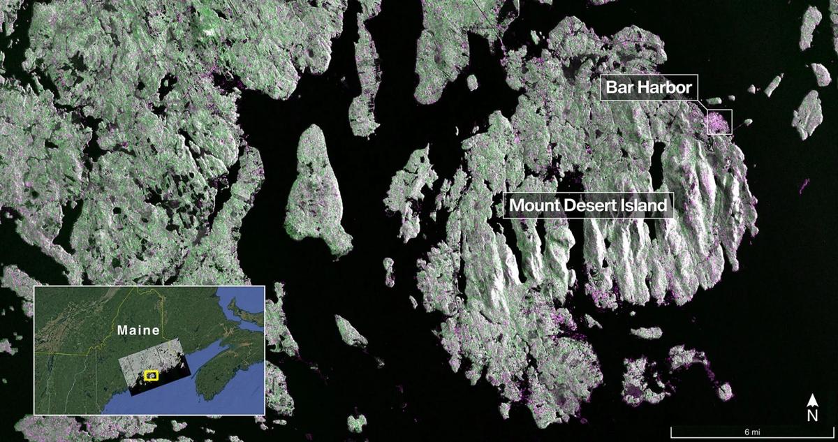
The mission has also sparked excitement among students and young researchers in India. Universities are planning workshops and training programs to help the next generation of scientists use NISAR’s data effectively. ISRO has announced that it will make large portions of the data publicly accessible, encouraging innovation and discovery across academic and industrial sectors. From developing AI models for crop forecasting to designing flood risk maps, students are expected to lead groundbreaking projects powered by NISAR’s observations.
Economically, the mission is expected to generate significant value. By reducing crop losses, optimizing water use, and preventing disaster-related damages, NISAR could indirectly save billions of dollars annually. The insurance industry, too, could benefit from accurate risk assessments based on satellite data, leading to better coverage for farmers and businesses. Experts argue that the cost of the mission is far outweighed by the long-term savings and benefits it will deliver to economies and communities worldwide.
The satellite’s first images have been widely shared on social media, capturing public imagination. Space enthusiasts in India are celebrating the achievement as another feather in ISRO’s cap, following the Chandrayaan and Aditya missions. The fact that India is at the center of such a historic project with NASA has instilled a sense of national pride. Citizens see it as proof of India’s growing leadership in space technology, while also recognizing its practical role in addressing everyday challenges faced by ordinary people.
Yet, experts caution that the true value of NISAR will depend on how effectively the data is used on the ground. While scientific institutions are well-prepared, local administrations may require training and capacity-building to translate satellite insights into actionable policies. Bridging this gap will be crucial to ensure that NISAR’s potential is fully realized. Government agencies, NGOs, and private companies will need to work together to integrate radar data into decision-making processes that affect millions of lives.
Looking ahead, NISAR is seen as a stepping stone for even more ambitious Earth observation projects. Space scientists believe that the success of this mission could lead to a new generation of radar satellites focused on specific challenges such as coastal monitoring, renewable energy planning, and ecosystem preservation. The collaboration model between NASA and ISRO is also expected to inspire future partnerships in space exploration, proving that when nations work together, they can achieve breakthroughs that are not possible in isolation.
Follow: Karnataka Government
Also read: Home | Channel 6 Network – Latest News, Breaking Updates: Politics, Business, Tech & More
