GIS survey: A comprehensive Geographic Information System survey has revealed that nearly 37% of lakes across Karnataka are affected by encroachment, raising serious concerns about environmental degradation, water security, and urban governance. The findings place Bengaluru’s districts among the worst performers, highlighting the severe strain rapid urbanisation has placed on the State’s traditional water bodies. Experts warn that the scale of encroachment threatens not only ecological balance but also the long-term sustainability of cities and rural regions alike.
Environmental economists have pointed out that the loss of lakes carries hidden financial costs that are often ignored in policy discussions. Flood damage to homes and infrastructure, increased expenditure on water supply projects, and rising public health costs linked to water scarcity all impose a heavy burden on the State exchequer. They argue that protecting and restoring lakes is not merely an environmental obligation but also a sound economic investment that can reduce long-term public spending.
Climate experts warn that lake encroachment will amplify the impacts of climate change in Karnataka. With rainfall patterns becoming increasingly erratic, cities and towns need natural buffers to absorb excess water during intense downpours and retain moisture during dry spells. Encroached and concretised lakes lose this buffering capacity, making urban areas more vulnerable to both floods and droughts, a pattern already evident in recent years.
Officials involved in urban governance have acknowledged that political will will be critical in translating the GIS findings into action. Eviction of encroachments, especially in densely populated areas, often triggers resistance and legal challenges. However, administrators note that failure to act decisively now will only worsen future crises, making eventual interventions more disruptive and costly.
Urban planners have also stressed the need to rethink development indicators that prioritise built-up area expansion over ecological health. They argue that cities must be evaluated not just on economic growth or infrastructure creation but also on the condition of natural assets such as lakes, wetlands, and green spaces. The GIS survey, they say, offers an objective benchmark to measure environmental governance performance.
Educational institutions and research bodies have called for the survey data to be integrated into academic and professional training for planners, engineers, and administrators. By embedding real-world spatial data into curricula, future decision-makers can develop a deeper understanding of the consequences of ignoring natural systems in development planning, fostering a more responsible governance culture.
Ultimately, the survey has reignited a broader public debate on the kind of urban future Karnataka envisions. Citizens, experts, and policymakers alike are being forced to confront uncomfortable questions about past choices and present priorities. Whether the stark revelation of widespread lake encroachment leads to meaningful reform or fades into another unheeded warning will shape the State’s environmental resilience and urban livability in the years ahead.
The survey, conducted using high-resolution satellite imagery and spatial mapping techniques, assessed the physical boundaries, catchment areas, and buffer zones of lakes across multiple districts. It found that a significant portion of lake beds, rajakaluves, feeder channels, and surrounding wetlands have been taken over by residential layouts, commercial buildings, roads, and even government infrastructure. Environmentalists describe the findings as a wake-up call that exposes decades of neglect and weak enforcement.
Bengaluru Urban, Bengaluru Rural, and parts of Ramanagara emerged as the most affected districts, with encroachments ranging from partial narrowing of lake boundaries to complete disappearance of smaller water bodies from official records. Once known as the “city of lakes,” Bengaluru has seen hundreds of interconnected tanks either shrink drastically or vanish entirely, disrupting natural drainage systems and groundwater recharge.
Officials involved in the survey said the use of GIS technology has brought unprecedented clarity to the extent of the problem. Unlike earlier manual surveys, which were often outdated or inconsistent, the digital mapping provides precise, tamper-resistant data that can be used for legal action, restoration planning, and policy formulation. Authorities acknowledged that the findings expose uncomfortable truths about governance failures over several decades.
The report has sparked concern across policy, environmental, and civic circles, particularly as Karnataka continues to face recurring floods during monsoons and water shortages during summer. Experts argue that lake encroachment lies at the heart of both crises, as blocked drainage channels lead to urban flooding while the loss of water bodies reduces natural storage capacity.
As public debate intensifies, the survey has placed renewed pressure on the State government and local bodies to move beyond rhetoric and take decisive action to protect and revive Karnataka’s rapidly vanishing lakes.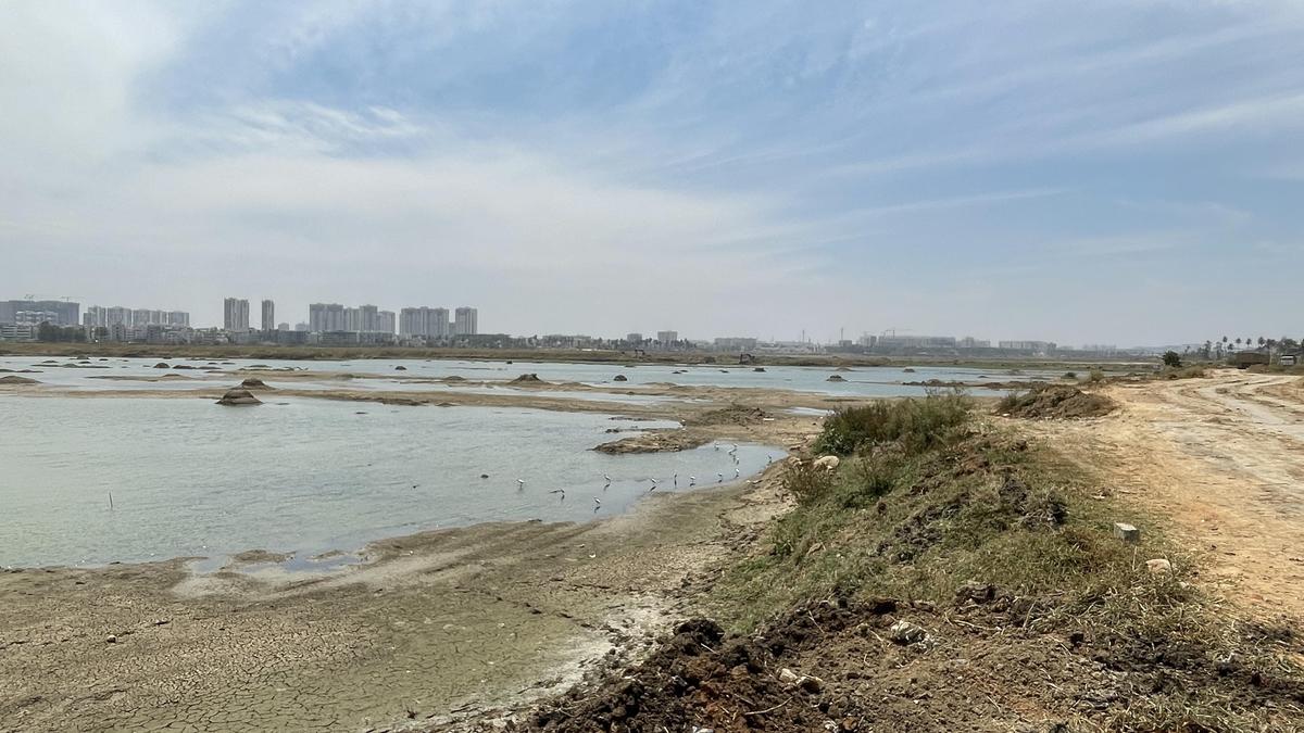
Bengaluru’s Lakes Under Severe Stress
The GIS survey paints a grim picture of Bengaluru’s lake ecosystem, revealing that a significant percentage of lakes in the city and its surrounding districts have been compromised. Encroachments were found not only on lake beds but also along feeder channels and buffer zones, areas critical for maintaining hydrological balance. Experts note that even minor narrowing of these zones can disrupt water flow and reduce a lake’s capacity to absorb excess rainfall.
Urban planners attribute the crisis largely to unplanned expansion and weak regulatory oversight. As Bengaluru grew into a major technology and economic hub, land values soared, creating immense pressure on open spaces and water bodies. Over time, lakes were viewed less as ecological assets and more as vacant land available for development. This mindset, experts say, has had devastating consequences.
The survey revealed that many encroachments occurred gradually, often with tacit administrative approval or delayed enforcement. In several cases, residential layouts and commercial complexes were developed after feeder channels were diverted or covered, permanently altering natural drainage patterns. These changes, environmentalists argue, directly contribute to flooding in low-lying areas during heavy rainfall.
Officials admitted that multiple agencies share responsibility for lake management, leading to fragmented oversight. Revenue departments, urban local bodies, development authorities, and environmental agencies often operate in silos, allowing encroachments to slip through gaps in jurisdiction. The GIS survey, by consolidating data across regions, has exposed the cost of this lack of coordination.
The impact on groundwater levels has also been severe. Lakes traditionally acted as recharge zones, replenishing aquifers that supplied water to wells and boreholes. With encroachments reducing lake surface area and depth, groundwater recharge has declined, forcing greater dependence on distant water sources and deep borewells.
Residents’ groups in Bengaluru have expressed alarm at the findings, stating that the survey validates long-standing concerns raised by citizen activists. Many argue that community-led lake protection efforts have often been undermined by official inaction, despite repeated warnings about the consequences of encroachment.
The findings have also raised questions about the accountability of past administrations. Environmental lawyers point out that court orders protecting lakes and buffer zones have existed for years, yet violations continued largely unchecked. The GIS data now provides concrete evidence that could be used to pursue enforcement and restoration.
Statewide Implications and the Road Ahead
While Bengaluru districts dominate the list of worst performers, the survey makes it clear that lake encroachment is a statewide issue. From rapidly urbanising tier-two cities to rural regions facing agricultural pressure, lakes across Karnataka are under threat. Experts warn that ignoring the problem outside major cities could lead to similar crises in smaller towns in the coming years.
Environmental scientists emphasise that lakes are not isolated features but part of interconnected watershed systems. Encroachment on one lake can affect downstream water bodies, increasing flood risk and reducing water availability across entire regions. The loss of wetlands and marshes further exacerbates climate vulnerability, as these ecosystems act as natural buffers against extreme weather.
The State government has described the GIS survey as a foundational document for future action. Officials indicated that the data will be used to identify priority lakes for restoration, initiate eviction of encroachments where legally feasible, and strengthen monitoring mechanisms to prevent future violations. However, they acknowledged that enforcement will be politically and socially challenging.
One of the key challenges lies in balancing environmental protection with human concerns. In several cases, encroachments involve long-settled communities or essential infrastructure. Experts argue that restoration efforts must be accompanied by fair rehabilitation policies to avoid humanitarian crises while still reclaiming critical ecological spaces.
Urban policy analysts have called for a single empowered authority to oversee lake protection, citing the failure of fragmented governance models. They argue that without clear accountability and consistent enforcement, even the most accurate surveys risk becoming mere documentation exercises rather than catalysts for change.
The findings have also renewed calls for integrating lake protection into urban planning processes. Experts stress that master plans must treat water bodies and drainage networks as non-negotiable elements rather than obstacles to development. Incorporating GIS data into planning approvals could help prevent encroachments before they occur.
Citizen participation is seen as another crucial component of long-term protection. Environmental groups argue that local communities must be empowered to monitor lakes, report violations, and participate in restoration efforts. Transparency in sharing GIS data with the public could strengthen civic oversight and reduce opportunities for illegal occupation.
Legal experts note that the survey strengthens the evidentiary basis for judicial intervention. Courts have increasingly relied on scientific data in environmental cases, and the GIS findings could play a key role in future litigation aimed at protecting lakes and wetlands across the State.
As Karnataka grapples with the dual challenges of urban flooding and water scarcity, the survey’s findings underscore the urgent need for decisive, coordinated action. Restoring lakes is no longer just an environmental concern but a necessity for urban resilience, public safety, and sustainable development.
In conclusion, the revelation that 37% of Karnataka’s lakes are encroached upon is both alarming and instructive. It exposes the cumulative impact of decades of unplanned growth, weak enforcement, and undervaluation of natural resources. At the same time, it offers an opportunity to reset priorities using technology-driven insights. Whether the State chooses to act decisively on this knowledge will determine not only the future of its lakes but also the quality of life for generations to come.
Follow: Karnataka Government
Also read: Home | Channel 6 Network – Latest News, Breaking Updates: Politics, Business, Tech & More
