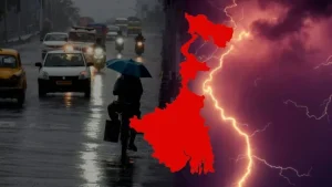
The India Meteorological Department (IMD) has issued an orange alert for West Bengal and Odisha, warning of heavy rainfall, thunderstorms, and lightning between March 20 and March 22, 2025. The alert signifies a moderate to high risk of disruption in daily activities due to extreme weather conditions.
With moisture incursion from the Bay of Bengal and unstable atmospheric conditions, thunderstorms are expected to intensify, affecting several districts. Authorities have urged residents to take necessary precautions as gusty winds, flash floods, and power disruptions could follow.
This weather event raises concerns about agricultural damage, urban flooding, and travel delays, making it crucial for citizens to stay informed and prepared.
IMD’s Weather Forecast: What to Expect?
According to the IMD’s latest bulletin, multiple factors are contributing to the extreme weather:
- Strong moisture incursion: Winds carrying moisture from the Bay of Bengal are fueling the storm system, leading to sustained heavy rainfall.
- Unstable atmospheric conditions: The combination of warm air at lower levels and cooler temperatures at higher altitudes is creating instability, leading to the formation of cumulonimbus clouds, which cause thunderstorms and heavy showers.
- Gusty winds: Wind speeds could reach 40-50 km/h, posing a risk to weak structures, trees, and power lines, potentially leading to power outages and transportation disruptions.
- Low-pressure system intensification: A developing low-pressure area over the Bay of Bengal is expected to strengthen, further enhancing rainfall intensity across affected regions.
- Coastal and riverine flooding risks: Continuous heavy rainfall may lead to waterlogging in urban areas, flash floods in low-lying regions, and rising water levels in rivers.
- Drop in temperature: The persistent cloud cover and rainfall will likely cause a significant dip in temperatures, making conditions cooler than usual for this time of year.
- Lightning and thunderstorm activity: Frequent lightning strikes pose a serious threat to human and animal life, with rural areas and open fields at higher risk.
These combined factors indicate that the next few days will be critical, requiring residents and authorities to stay vigilant and take necessary precautions.

Regions Expected to Be Affected
IMD’s orange alert primarily covers the following regions:
In West Bengal:
- Kolkata
- Howrah
- Hooghly
- Midnapore
- Purulia
- Bankura
- North and South 24 Parganas
In Odisha:
- Bhubaneswar
- Cuttack
- Puri
- Ganjam
- Balasore
- Kendrapara
These areas will likely experience intense thunderstorms, leading to temporary waterlogging, traffic congestion, and power disruptions.
Historical Comparison:
- In 2022, Kolkata recorded 140 mm of rainfall in a single day, leading to widespread waterlogging, traffic congestion, and disruption of daily life.
- Odisha witnessed severe flooding during Cyclone Yaas in 2021, when over 250 mm of rain fell in a short period, causing widespread damage in coastal areas.
- In August 2015, Kolkata experienced its heaviest single-day rainfall in a decade, receiving 144 mm of rain, which resulted in knee-deep water in several parts of the city and halted public transport.
- Cyclone Amphan in May 2020 brought torrential rainfall exceeding 200 mm in many parts of West Bengal, uprooting trees, damaging infrastructure, and disrupting power supply for days.
- During the 2018 monsoon, Odisha’s Malkangiri district recorded an extreme 300 mm of rainfall within 24 hours, triggering flash floods that displaced thousands of residents.
- In 2007, the Bengal floods affected over 10 million people, with heavy rainfall exceeding 250 mm in multiple districts, submerging vast agricultural lands and crippling transportation networks.
- The 1999 Odisha Super Cyclone dumped more than 400 mm of rain over several days, causing catastrophic flooding and becoming one of the deadliest cyclones in Indian history.
These historical records highlight the vulnerability of West Bengal and Odisha to extreme weather events, underscoring the need for disaster preparedness and early warning systems to mitigate risks.
Authorities’ Response to Rainfall Alert:
- Municipal corporations in Kolkata and Bhubaneswar have activated emergency teams to clear clogged drains.
- NDRF teams are on standby in flood-prone districts.
- Fishermen have been advised to avoid venturing into the sea, as rough conditions are expected along the Bay of Bengal coast.
Impact of Rainfall and Thunderstorms
The IMD has warned about various consequences that may arise due to heavy rainfall and stormy conditions. These include:
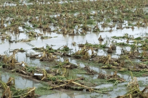
1. Agricultural Losses
- Standing crops like paddy, wheat, and vegetables could suffer damage due to strong winds and excessive rain.
- Farmers are advised to take protective measures, such as harvesting ripe crops early and covering vulnerable plants.
- Paddy fields and vegetable crops in Midnapore, Bankura, and Balasore could suffer damage due to prolonged water exposure.
2. Lightning Strikes and Safety Concerns
- Lightning strikes pose a significant risk, especially in rural and open areas.
- People working in fields or traveling outdoors must take shelter in safe places to avoid accidents.
3. Urban Disruptions
- Waterlogging in low-lying areas of Kolkata, Bhubaneswar, and other metro regions could cause traffic snarls. With multiple districts expected to receive over 100 mm of rainfall, low-lying areas and poorly drained urban zones may experience significant water accumulation.
- Rail and air transport may face delays, particularly in major cities like Kolkata and Puri.
4. Power and Communication Disruptions
- The possibility of power outages remains high due to falling trees and damaged power lines.
- Internet and mobile network disruptions could also occur in storm-affected areas.
5. Flooding Risks
- With multiple districts expected to receive over 100 mm of rainfall, low-lying areas and poorly drained urban zones may experience significant water accumulation.
How to Stay Safe: Precautionary Measures
IMD and disaster management authorities recommend following these safety tips to minimize risks:
For General Public:
1. Stay indoors during thunderstorms – Avoid going outside unless absolutely necessary.
2. Avoid sheltering under trees or electric poles – These structures are prone to lightning strikes.
3. Keep emergency supplies ready – This includes flashlights, power banks, dry food, and first aid kits.
4. Monitor weather updates – Rely on official weather sources like the IMD website or local government bulletins.
For Farmers and Rural Communities:
1. Harvest crops early if possible to prevent losses.
2. Store harvested produce in dry and secure areas.
3. Avoid working in open fields during thunderstorm warnings.
For Commuters and Travelers:
1. Check train and flight schedules in advance, as delays are expected.
2. Avoid waterlogged roads to prevent vehicle breakdowns or accidents.
3. Carry rain gear and emergency supplies if traveling during alert periods.
Expert Insights: What Meteorologists Are Saying
Weather experts believe that climate change and changing monsoon patterns are influencing the frequency of extreme weather events in India.
Dr. Anupam Roy, a meteorologist at IMD Kolkata, stated, “We have observed a significant increase in pre-monsoon thunderstorms in the eastern region. This orange alert is necessary as the atmospheric instability is higher than usual. We advise citizens to follow safety guidelines strictly.”
Dr. Meera Sen, a climate researcher, added, “Global warming is leading to more extreme weather conditions. Sudden temperature changes and moisture inflow from the Bay of Bengal are triggering these heavy thunderstorms more frequently.”
Government and Disaster Response Measures
The state governments of West Bengal and Odisha have activated emergency response teams to handle possible disruptions.
- NDRF and SDRF teams are on standby for evacuation and rescue operations.
- Local municipalities are clearing drainage systems to prevent severe waterlogging.
- Disaster helplines have been set up to assist citizens during emergencies.
Climate Change and Its Role in Extreme Weather
The increasing frequency of extreme weather events in India raises concerns about climate change.
Why Are Thunderstorms Becoming More Common?
- Higher temperatures lead to more moisture in the atmosphere, fueling intense storms. Deforestation and urbanization are affecting natural wind and rain patterns.
- Sea surface temperature rise in the Bay of Bengal is making cyclonic disturbances stronger.
What Can Be Done?
- Strengthening early warning systems to provide timely alerts.
- Implementing sustainable urban drainage solutions to combat flooding.
- Promoting reforestation and afforestation projects to regulate local climates.

The IMD’s orange alert for West Bengal and Odisha highlights the serious impact of heavy thunderstorms and rainfall expected in the coming days. With the increasing frequency of extreme weather events, it is crucial for residents to remain alert and take necessary precautions to ensure safety.
Severe weather conditions can cause urban flooding, agricultural losses, power outages, and transportation disruptions, significantly affecting daily life. The impact on farmers, whose crops may suffer extensive damage, adds another layer of concern, especially for regions heavily dependent on agriculture. Additionally, lightning strikes, strong winds, and waterlogging could lead to road accidents, property damage, and delays in emergency services.
To minimize risks, authorities have urged people to stay informed, follow safety guidelines, and prepare emergency supplies. Those living in low-lying areas must take extra precautions, as heavy rainfall may lead to flash floods. The government has deployed disaster response teams to handle emergencies, and residents should remain in contact with local authorities for real-time updates.
This extreme weather event also raises concerns about climate change and shifting weather patterns, which are making storms more intense and unpredictable. Experts suggest that rising global temperatures and increased moisture levels in the atmosphere are contributing to stronger thunderstorms and heavier rainfall. As such, long-term strategies must be implemented, including improved urban drainage systems, better disaster preparedness, and sustainable climate policies to mitigate future risks.
With the IMD’s timely warnings, residents have an opportunity to prepare in advance, avoid unnecessary travel, and take necessary safety measures. By staying informed, proactive, and cautious, people can reduce potential damages and protect themselves and their families from the adverse effects of this extreme weather event.
For real-time weather updates, citizens are encouraged to follow IMD’s official website, state emergency bulletins, and local news channels.
Read More: https://channel6network.com/kolkata-heatwave-alert-2025/
