Sundarbans Fishing Boats Equipped: On the occasion of Global Tiger Day 2025, the West Bengal Forest Department, in collaboration with the Wildlife Trust of India (WTI) and Lokamata Rani Rashmoni Mission, launched a pilot program to provide GPS-enabled SOS devices to licensed fishing boats operating in the Sundarbans region. This move aims to ensure faster emergency response and reduce human-tiger conflict in the world’s largest mangrove ecosystem.
Sundarbans Fishing Boats Equipped: How the GPS-SOS System Works
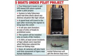
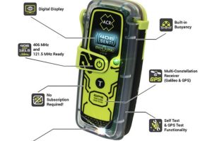
The GPS device, installed on five pilot boats in Kultali block of South 24 Parganas, has a single-button emergency feature. In case of a tiger attack or distress, fishermen can press the button to trigger a real-time alert that sends their GPS location to a rapid response team.
This team includes forest officials, wildlife responders, and trained medics who arrive by motorized boats equipped with rescue gear and first-aid supplies.
Eligibility Tied to Licensed Operation
The initiative is strictly limited to fishing boats holding valid Boat License Certificates (BLCs). This eligibility criterion discourages illegal fishing and reinforces the importance of regulated access to forest zones. Officials have stated that many recent tiger encounters occurred due to fishermen venturing deep into core tiger habitats, often without valid permits.
The GPS system also allows authorities to monitor movement and prevent unauthorized entry into protected zones.
A Growing Need Amid Rising Conflicts
The Sundarbans is home to around 180 Royal Bengal Tigers, and human-tiger encounters remain frequent due to the overlapping territories of people and wildlife. In 2024, at least seven fatal tiger attacks were recorded, with many incidents involving fishermen entering forest creeks for crab collection or fishing.
These attacks often result in delays in medical response due to a lack of precise location data. The GPS-SOS solution aims to close this critical gap by enabling real-time monitoring and targeted rescue.
AI Surveillance and Camera Traps in the Pipeline
In the next phase of the project, AI-based camera traps will be installed in sensitive riverbanks and forest-adjacent villages. These cameras will send automatic alerts to forest teams when tiger activity is detected, offering early warnings to residents and local patrols.
This system is being developed with support from IUCN, German Cooperation (KfW), and WTI’s wildlife conflict mitigation program. Officials say this technology-backed surveillance network will help reduce both animal casualties and human deaths.
Response Team and Community Engagement
The SOS alerts will be received at the Range Officer’s office, triggering an immediate response from a patrolling speedboat. The team includes local Primary Response Team (PRT) volunteers trained in conflict mitigation and wildlife safety.
Workshops are being organized for boat owners and BLC holders to demonstrate the GPS system and create awareness about do’s and don’ts in tiger territory.
Broader Trends in Maritime Safety
This Sundarbans initiative aligns with broader government efforts to improve maritime safety. The Indian Space Research Organisation (ISRO) has launched a satellite-based transponder project for deep-sea trawlers in West Bengal, allowing real-time location tracking and emergency communication beyond mobile network coverage. The project will equip 500 trawlers initially, with plans to expand to over 17,000 vessels.
While the ISRO system is intended for deep-sea vessels, the Sundarbans GPS project is uniquely tailored for forest-area fishing with higher wildlife conflict risks.
Community Reactions and Early Feedback
Local fishermen have responded with cautious optimism. While some are hesitant about being monitored, many see this as a vital step toward saving lives and reducing fear. “If help can reach us in minutes, it will give us the courage to work safely,” said Gopal Das, a BLC-holder in Kultali.
Others expressed concern about privacy, but officials clarified that the GPS is activated only when the SOS button is pressed, and not used for continuous surveillance unless necessary.
Looking Ahead: Scaling and Integration
The pilot project is expected to expand across the Sundarbans region after analyzing field data. The aim is to eventually cover all licensed fishing boats operating near core tiger habitats.
Future plans include integrating this system with district disaster management networks, enabling faster coordination during cyclones or medical emergencies unrelated to tiger encounters.
Experts believe that combining community awareness, modern tracking, and AI-assisted surveillance can create a long-term sustainable coexistence model in the Sundarbans.
Why It Matters
The Sundarbans presents a unique conservation challenge—it is a UNESCO World Heritage Site, a biosphere reserve, and also the workplace of thousands of fishermen. As climate change increases habitat pressure and sea levels rise, conflicts between humans and tigers are expected to grow unless proactive steps are taken.
This initiative represents a convergence of technology, policy, and community action—ensuring both human safety and wildlife protection in one of the most ecologically sensitive zones of the planet.
External Sources for Further Reading:
- Wildlife Trust of India (WTI)
- Ministry of Environment, Forest and Climate Change, India
- UNESCO – Sundarbans Biosphere Reserve
- ISRO – Indian National Centre for Ocean Information Services (INCOIS)
- IUCN – Human-Wildlife Conflict Guidelines
- The CSR Journal – Tiger Conservation & Coastal Safety
Also read: Home | Channel 6 Network – Latest News, Breaking Updates: Politics, Business, Tech & More
